Research Overview
|
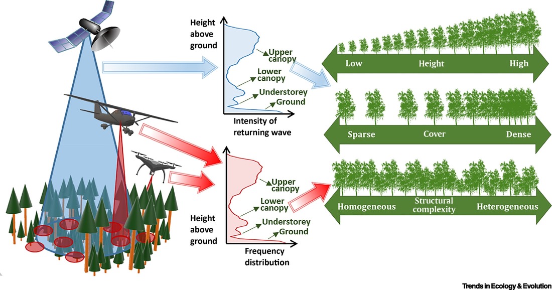
Forest structure, and structural complexity, have often been used as predictors for forest successional stage. Forest structure itself can be defined as the distribution of foliage and woody mass within a forest. As the distribution of leaf and woody mass is determined by the species present, and species presence often determines successional stage, all of these concepts can be linked. Thus this project is using structure as an indicator of succession. To measure the forests structure without intensive intervention on a large-scale, we can implement remote sensing technologies. In my project, I utilize light ranging and detection (LiDAR), specifically full-waveform LIDAR. Full-waveform LiDAR is separate from discrete-return LiDAR due to it recording the entire returned energy wave rather than just the peaks. The full digitization allows for every interaction to be recorded.
By understanding how forest structure can predict succession on a large-scale, long-term monitoring efforts can be conducted with minimal direct intervention. Long-term monitor can provide invaluable information on targeted recovery, protected areas, and any other experimental or natural regeneration efforts. |
Summary
|
This study plans to assess the validity of using full-waveform lidar metrics as a means to predict and map forest structure, broadly classed as succession. Approximately 60 training plots were used to classify 3 separate classes (early, intermediate & late). Each training data site has previously been classified by their stage in other studies. The method of analysis chosen mirrors that which was presented in Unit 4 (CANDISC, LDA, MANOVA) and those in Unit 8 (RandomForest and CART). Being able to classify large regions of interest based on a smaller number of training data sites is invaluable. This mean that large scale planning and monitoring efforts can be targeted even if the site may not have been previously visited.
|


