Forest structure
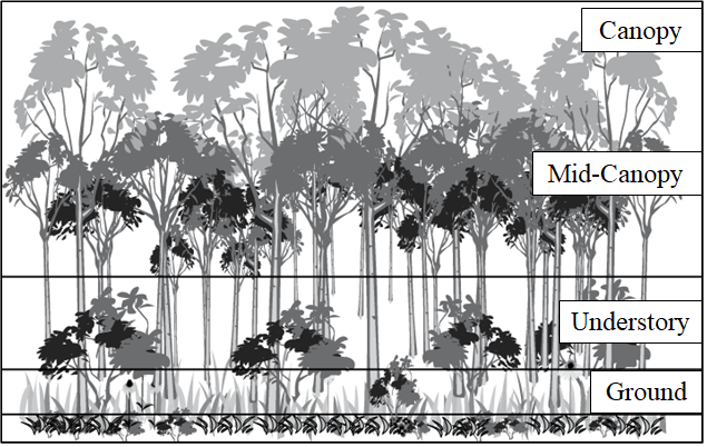
Forest structure can broad be considered as the vertical and horizontal distribution of biomass within a forest. Complexity is often used as a descriptor with respect to forest structure. An example would be in the image below, we can see that vertically the forest exhibits fairly large variability as such an increased complexity, but horizontally, the distribution is rather invariable. The goal of this study is to capture the vertical component of forest structure within each waveform footprint and be able to classify it using apriori classifications of a training dataset.
(Bottom) This image provides a visual representation of the parts involved with overall forest structure. There is: canopy, mid-canopy, understory and ground with the possible addition of a shrub-layer before the ground. These structural components will typically form with forest maturity, meaning that an early stage forest may not have all of these components, but a matured late stage forest likely will. Thus we assume that will stage maturity, structural complexity will increase.
(Top) The profiles shown in green are simulated waveforms create from a 2021 discrete LiDAR collection, these will form the foundation for the 2021 class predictions. (A) represents an early class waveform, (B) an intermediate, and (C) a Late.
(Top) The profiles shown in green are simulated waveforms create from a 2021 discrete LiDAR collection, these will form the foundation for the 2021 class predictions. (A) represents an early class waveform, (B) an intermediate, and (C) a Late.
Importance
With increasing attention towards human impacts on our natural environment, swaths of previously human-modified land is being turned over into secondary growth. Tropical forests are amongst the most disturbed and modified landscapes for the purpose of agriculture and human-expansion. Because of this, much of the forest in regions such as Costa Rica is considered secondary forest (Chazdon, 2014). Natural regeneration supports biodiversity and promotes functionality with ecosystem goods and services (Chazdon, 2017). Specific the the Guancaste region in Costa Rica, there was an increase in forest cover from 24% to 51% by natural regeneration alone (Calvo-Alvarado et al., 2019). Understanding how quickly and where this regeneration takes place is highly important if we are to understand how the landscape will function in coming years.
Typical tropical forest regeneration follows the trajectory from early stages, through transitions to intermediate then ultimately what is considered late stage or synonymous with old growth. Early stages are indicated by a relatively homogenous canopy layer that is rather short in stature, with the potential for pioneer individuals that break through (Montgomery & Chazdon, 2001). Later stages develop greater complexity, perhaps exhibiting 3 or more strata, and a much greater level of species diversity (Ruiz-Jaen & Potvin, 2011). Complexity is often interchanged with structure, thus as the successional trajectory continues the structure is becoming more developed and full.
Since these changes are occurring on such broad, landscape-scales, inventories and efforts to characterize the forest can be extremely labour intensive. To mediate this, remote sensing techniques and technologies can be utilized. Imaging systems can provide phenological information and biophysical data using spectral reflectance, which has been a well-described methodology for several decades. More recently, 3D structural information has been highlighted by use of LiDAR (light detection and ranging). LiDAR is an active remote sensing technology capable of capture the forests 3D structure with high accuracy and density (Almeida, Stark, Valbuena, et al., 2019). Successional changes specifically, may be characterized through LiDAR 3D structural metrics allowing for long-term monitoring, modelling and possibly prediction related to succession (Almeida, Stark, Chazdon, et al., 2019; Caughlin, Rifai, Graves, Asner, & Bohlman, 2016). Because of these possibilities, this project will explore the application of statistical classification methods to LiDAR forest metrics for the purpose of successional stage prediction.


